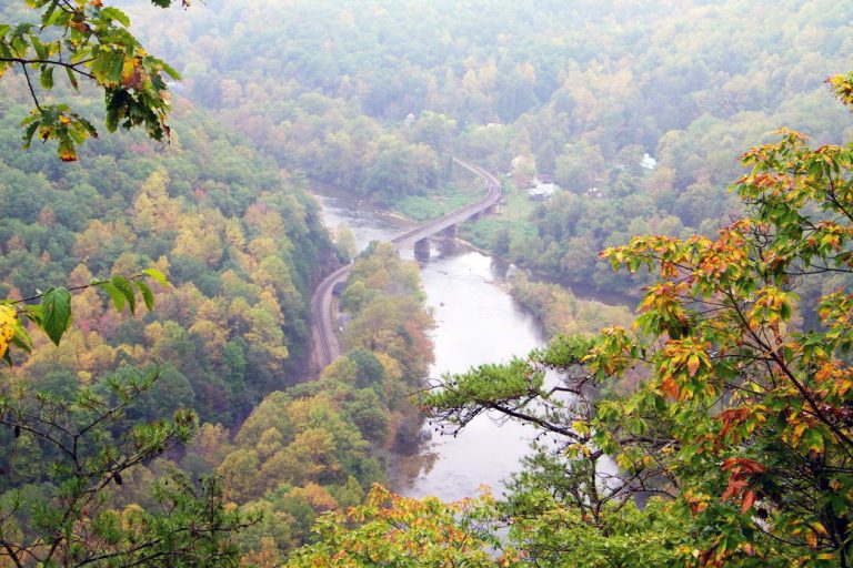
In the heart of the East Tennessee mountains, a ribbon of rushing water twists and turns its way through one of the wildest, steepest gorges in the eastern United States. The river is known far and wide for its bounty of fish, its tumbling rapids, and its isolation amid remote national forest land. It beckons boaters, anglers, and lovers of wild places who go searching to see just how natural and free a river can be.
This is the Nolichucky River, and it carves a rugged, 115-mile path from western North Carolina down into Northeast Tennessee, passing through two national forests and several mountain ranges along the way. It originates at the confluence of the Toe and Cane rivers near the summit of Mount Mitchell, which, being the highest point east of the Rockies, is the reason for the Noli’s notably cool temperatures. The Nolichucky eventually concludes its winding journey near Morristown, Tennessee, where it joins the French Broad River.
What Makes It Special
The origin of the river’s unusual name is something of a mystery, though most people agree that it’s an adaptation of the Cherokee word nana-tu-gluncky. The confusion lies with the translation, which is either “Spruce Tree Place,” “Rushing Waters,” or “Dangerous Waters,” depending on whom you ask. We may never know which of these meanings was intended by the Cherokee, but any one of them seems quite fitting for the Nolichucky as we know it today.
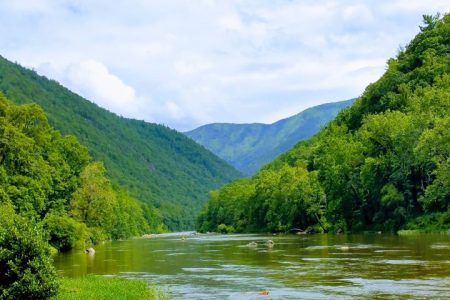
The Nolichucky is one of the last major free-flowing (undammed) rivers in the Southeast, and thus its water levels vary dramatically throughout the seasons. At times it can be too high or low for recreation, but its scenery is enjoyable year-round. Much of the river rests at the bottom of a deep gorge with bluffs rising more than 2,000 feet above the swift rapids, creating an epic canyon-like landscape that’s truly unique in the Southeast.
River History
Human history along the Nolichucky has taken almost as many fascinating twists and turns as the river itself. The Chickamauga Cherokee inhabited the area when European frontiersmen established settlements along the river in the 1770s. Among these was the Nolichucky Settlement, established by young John Sevier in what is now Greene County. Extreme opposition from Native Americans caused Sevier to abandon the settlement in 1776.
The Nolichucky’s banks also saw the birth of David Crockett, one of Tennessee’s most famous early politicians. Crockett was born near Limestone, Tenn., at a place now designated as David Crockett Birthplace State Park. When you visit the park you’ll find a wonderful history exhibit, gentle walking trails, and access to a placid section of the Nolichucky that’s great for flatwater paddling and fishing.
Another interesting site along the river is the Lost Cove Settlement, a once-prosperous logging and mining town nestled in a dense riverside forest. The town’s population slowly declined until it was finally abandoned in 1957. Today, the site is home to a cemetery, a few dilapidated houses, and various other remnants of civilization, and you can reach it via a 2.5-mile hike down the Lost Cove Trail.
Paddling on the Nolichucky
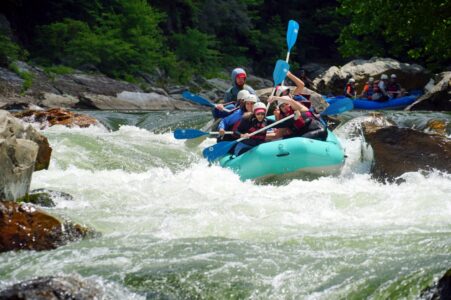
By far the most popular way to experience the Nolichucky is to get up close with its revered whitewater. A stretch of river measuring about eight miles between Poplar, N.C. and Erwin, Tenn., offers boaters continuous and diverse Class III and IV rapids that strike the perfect balance between challenge and fun.
The first half of the run is consistently demanding, beginning with the Class III+ Entrance rapid and continuing through Quarter Mile (Class IV) and Roostertail (Class III+). This playful section of the river is characterized by large boulders, big waves, and an average descent of 66 feet per mile.
Around the halfway point the river mellows slightly, allowing boaters to relax a bit and enjoy the scenery of the Nolichucky Gorge. The highest water levels are typically found in March through June, and the lower flow in the later summer months tends to be better for less-experienced paddlers.
Most paddlers choose to launch from the U.S. Forest Service Poplar Boat Launch in and make their way down to the takeout at Nolichucky Gorge Campground, which offers paid parking and showers for private boaters.
USA Raft Adventure Resort and Blue Ridge Paddling both offer expert rafting trips down the Nolichucky, which makes an exciting and unique family or group outing. This is the perfect way to experience the beautiful Nolichucky with a professional guide who is familiar with the river and its many rapids.
Fishing on the Nolichucky
For anglers, several sections of the Nolichucky are a dream come true. The river offers world-class fishing for a variety of bass, including smallmouth, rock, and black bass. There’s also plenty of opportunities to catch catfish, crappie, musky, and trout.
In the winter months, the upper part of the Nolichucky is stocked with rainbow trout from the nearby Erwin National Fish Hatchery. Just below Erwin and the whitewater takeout, the water is somewhat quick-flowing but calm enough to fish by wading or drifting.
Arguably the best spot for smallmouth bass fishing is just below the dam on the lower Nolichucky in Greene County, which can be accessed from the boat launch at Easterly Bridge. In all, the Nolichucky is considered by many to be one of the top three angling rivers in East Tennessee.
Whether you choose to explore the Nolichucky River and its surrounding wilderness by raft, on foot, or with a fishing rod in hand, there’s no doubt that you’ll discover something magical on your journey through this wild and wonderful gorge. Its ever-changing waters and fascinating history are sure to keep you coming back to Northeast Tennessee again and again.
Written by Madison Eubanks for RootsRated Media in partnership with Northeast Tennessee Tourism.
Featured image provided by Brian Greer