Follow along with outdoorsman and writer Johnny Molloy as he treks through the mountains of Northeast Tennessee.
From the mountain lined water of Watauga Lake, you’ll find a ridge rising from the north just along the Appalachian Trail. Make the hike to Vandeventer, and you’ll be greeted with ribbons upon ribbons of smoky blue mountains as far as the eye can see.
As an added bonus, your hike to the views of Vandeventer will travel through the Laurel Branch Wilderness Area, where occasional outcrops provide warm-up vistas for the main event. The richly forested mountain eventually takes you to the Vandeventer Shelter along the Appalachian Trail. Directly behind the shelter, you’ll see panoramic views of Watauga Lake dotted with islands.
Make It an Overnight Hike

From Watauga Dam, Vandeventer is 4.6 miles one-way. That makes a 9.2 mile round-trip hike. Some hikers will want to bring their sleeping bag, and other essentials, to make an overnight trip to the Vandeventer Shelter. It that’s your style, you’ll enjoy a 360-degree view of an Appalachian sunrise the next morning.
The Hike
From the trailhead near Watauga Dam, leave Iron Mountain Gap, northbound on the Appalachian Trail. Immediately reach a sign indicating the Laurel Branch Wilderness Area, a federally designated wild area encompassing the crest of Iron Mountain and its tributaries running down both sides of the ridge all the way to Watauga Lake. The wilderness is rich with wildflowers. Bears have been known to roam the mountain, too.
The main climb is over after one mile, but the ridge crest is often rocky and narrow.

The white-blazed Appalachian Trail continues tracing Iron Mountain, and black birch, red maple and goose foot maple trees become common with the increasing elevation. You are now above 3,000 feet. Reach a small spring at 3 miles. Climb out of the hollow to rejoin the top of Iron Mountain at 3.3 miles, as the ridge narrows.
The Appalachian Trail continues to play tag with the crest, going atop where it can, sometimes retreating to a side slope when the rocks are too strenuous. At 4.5 miles, look left for a blue-blazed spur trail descending to a chilly spring (this is the spring used by backpackers staying at Vandeventer trail shelter). But, continue to stay straight with the Appalachian Trail.
The Views
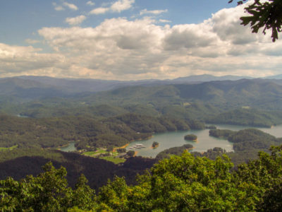
You’ll reach the Vandeventer trail shelter at 4.6 miles. A rock outcrop rises beyond the shelter. Below, Watauga Lake forms a flat shimmer pocketed with islands, peninsulas and coves, as Pond Mountain and White Rocks Mountain frame the lake. In the distance Roan Mountain, Grandfather Mountain and myriad peaks of North Carolina’s Pisgah National Forest extend to horizon’s end.
The Area
Near the trailhead, TVA’s Wilbur Dam and Watauga Dam area have picnic areas, boat launches, and even a campground.
Leave No Trace
Remember to leave our trails with no trace, so adventures can last a lifetime. Find out how you can make a difference with our leaders for litter-free Tennessee efforts.

Johnny Molloy is the author of many outdoor guides including Best Tent Camping: Tennessee, Paddling Tennessee, and Five Star Trails Tri-Cities: East Tennessee and Southwest Virginia.