Follow along with outdoorsman and writer Johnny Molloy as he treks through the mountains of Northeast Tennessee.
The waterfalls of upper Laurel Fork are a lesser-visited area of Northeast Tennessee. Hikers travel a wild valley, lined with multiple streams, mini water falls, and ending at one of our favorites.
Tip: Wear close-toed shoes you don’t mind getting wet, and bring trekking poles, or a hiking stick for unavoidable stream crossings.
The Hike
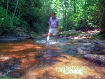
Start your trek at Dennis Cove Campground, then work your way into upper Laurel Fork, following old railroad tracks. It won’t be long before you make it to the first of 12 creek crossings along this 7.7 mile round trip hike.
And while you are there, the big pools of Laurel Fork call for a mountain swim. As you follow the Laurel Fork Trail, the Cherokee National Forest transforms into a jungle-like scene with dense woodland of yellow birch, black birch, cherry and maple trees, under which thrive masses of rhododendron and dog hobble.
Reaching the first creek crossing at .5 mile, scan the water for brown and brook trout swimming beneath the tea-colored water. Walk a short distance to the second crossing and climb to pass through a rock-walled opening. Here, the railroad blasted straight through a horseshoe bend in Laurel Fork.
Coming to the third crossing at .6 mile, watch out for deep spots and irregular boulders. After making it through the first three crossings, you can proceed with confidence.
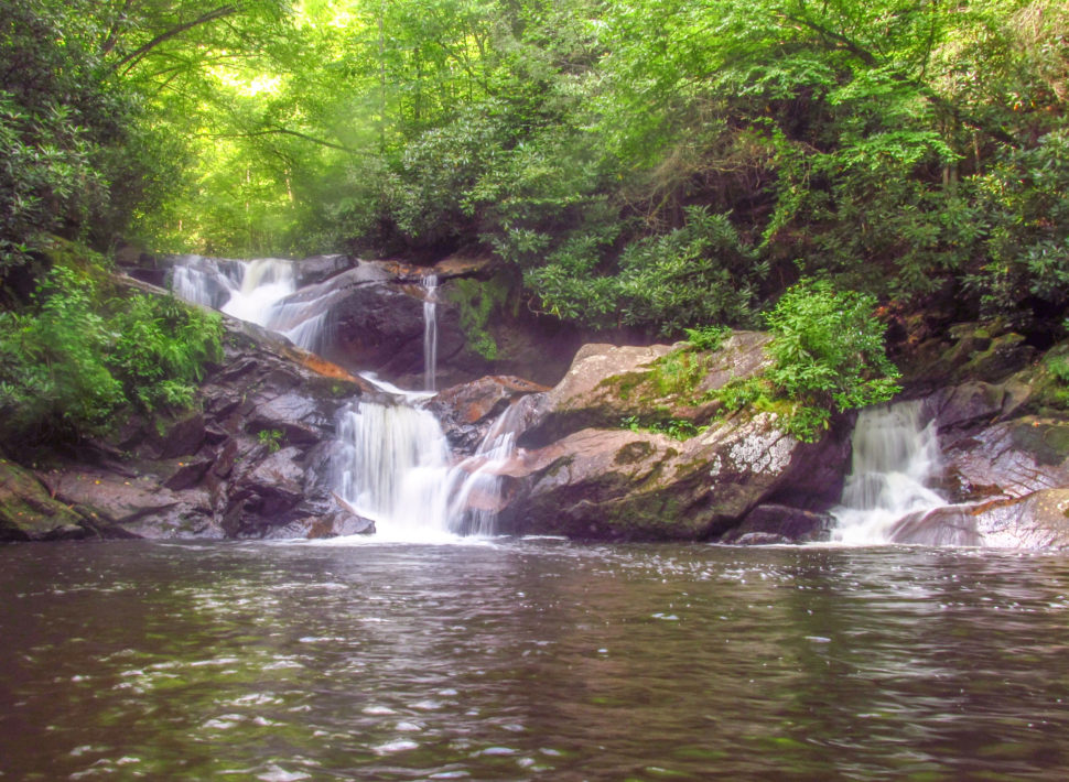
Lose yourself here, cruising along the gorgeous creek, where slides and shoals divide dusky pools. At 1.0 mile, a spur trail leads right to the creek. This is False Dennis Cove Falls, a 10-foot pour-over leading below to a swimming pool, framed in rhododendron. Continue upstream on the main trail.
Temporarily leave the old railroad grade, working past a sloped boulder on a rough hillside, and rejoin the grade at 1.1 miles. Next, you’ll head right on a narrow spur trail, snaking through dense rhododendron, to reach Dennis Cove Falls. The two-tiered Dennis Cove Falls drops 25 feet over an angled rock cleft.
Ahead, tunnel in thick woods until you reach your next creek crossing at 1.4 miles. This area is known for having beaver dams.
At 2.6 miles, after several more crossings, enter the large field of Frog Level. This mountain meadow is a sight to behold when late summer wildflowers rise among the grasses. At 2.8 miles, Lacy Trap Trail lies near a pond.
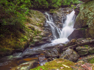
Stay straight on the Laurel Fork Trail, and look for old railroad ties embedded in the path. At 3.3 miles, make the twelfth and final crossing. Climb away from the stream on the right bank alongside Laurel Fork. Watch left, at 3.5 miles for a short spur going down to a loud waterfall.
Upper Laurel Fork Falls
Here, Upper Laurel Fork Falls makes a whitewater dive 18 feet over rock crevices, splashing mist over the stone walls and adjacent boulders before speeding downstream. The best viewing spots are covered in a river spray, so approach cautiously. Allow time to make the 12 crossings and 3.5 miles back to Dennis Cove.
Leave No Trace
Remember to leave our trails with no trace, so adventures can last a lifetime. Find out how you can make a difference with our leaders for litter-free Tennessee efforts.

Johnny Molloy is the author of many outdoor guides including Best Tent Camping: Tennessee, Paddling Tennessee, and Five Star Trails Tri-Cities: East Tennessee and Southwest Virginia.