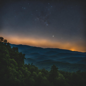
Explore the wonders of the Tennessee Night Sky! Embark on an extraordinary adventure through Northeast Tennessee’s night skies, where the universe comes alive! Several locations on the Tennessee Night Sky Trail are ADA Accessible with wheelchair accessibility.
Viking Mountain

Location: 36.02651390203208, -82.72069708325559
City: Greeneville
(ADA accessible from parking lot)
Viking Mountains’ name originated from the former 1960s ski resort that used to sit slightly below the summit. It’s rumored that during the peak of the ski resort, Elvis Presley was helicoptered onto the mountain. The actual name is Camp Creek Bald which sits within the Bald Mountains between the Tennessee and North Carolina border. However, locals refer to it as Viking Mountain. You can find the Appalachian Trail running just below the summit. Towering at 4,844 feet tall, Viking Mountain is just barely the second-highest peak in Greene County.
*AWD or 4WD vehicles are encouraged during rain or snow.
Crockett Springs Park & Arboretum
Location: 36.40376662087637, -83.00796882883569
City: Rogersville
(ADA accessible)
Crockett Springs Park located in Downtown Rogersville provides an escape from busy city life, as you sit back and and enjoy the night sky surrounded by history. It was on the 281 acre grant that Davis Crockett and his wife, Elizabeth Hedge Crockett, built their log cabin home near the large spring that would be known as Crockett Spring. The area park is also a certified arboretum. You may also enjoy a stroll through Historic Downtown Rogersville with a variety of shops and restaurants (hours vary).
Bays Mountain Park & Planetarium
Location: 36.50878760728313, -82.61020439368308
City: Kingsport
(Planetarium ADA accessible)
Whether you enjoy viewing the skies during the day or night, the field is stunning at *Bays Mountain Park. The *planetarium theater features utilizing fiber optics for each of the over 7,000 stars and deep sky objects. The park also hosts two observatories, telescopes, and observing programs. SunWatch is held each clear Saturday and Sunday by the dam from 3-3:30 p.m., March-October. StarWatch is held each Saturday in March, April, October, and November, starting at dusk at the observatories. If the weather is poor, an alternate activity will take place in the theater.
*Admission charge
South Holston Dam Spillway Trail
Location: 36.52064748773667, -82.09563207301413
City: Bristol
Hike Length: 3.5 miles round trip / moderate
This trail’s highlight is at the endpoint when you reach the shoreline of South Holston Lake with Holston Mountain towering in the background. If you chose to venture out in the summer, be on the lookout for wildflowers and even take a dip in the water, as you’ll be surrounded by the lush forest along the gravel trail. For the perfect photo opp, an excursion to South Holston Lake and Dam is a must for visitors to the area. The earth and rockfill dam, completed in 1950, spans 1,600 feet across the South Fork Holston River and is 285 feet high. During the day, South Holston is among the top lakes in Tennessee and the Southeast for boating activities and fishing.
Osborne Farm by the Appalachian Trail
Location: 36.481376, -81.961381
City: Shady Valley and Mountain City
(ADA accessible)
This half-mile stretch along the Appalachian Trail is flat and spacious, leading through an active farm where you will find various barns and a cranberry bog along the way. Acquired in 2001 by the United States Forest Service, highlights will come early once you reach the panoramic views in an open field and a bench to sit on that is perfect for star gazing. Come during the day, and you will find wide open skies and room for a picnic.
Roan Mountain on the Appalachian Trail
Location: 36.106453620906905, -82.11029863394087
Nearby City: Elizabethton
(ADA accessible from parking lot)
The top of Roan Mountain provides a great opportunity to escape city lights and enjoy the night sky surrounded by undeveloped national forest land. You can park at Carver’s Gap and hike the Appalachian Trail a half mile up to Round Bald (just be sure to bring a flashlight), view from the parking lot, or from one of the pull-off overlooks on the way up the mountain. Be aware that the road leading up to the Carvers Gap area hosts many curves, and visibility can be limited in fog. Roan Mountain State Park sits near the bottom of the mountain and provides a great base camp a short drive away with RV and tent camping as well as cabin rentals.
Chestoa Recreation Area (temporarily closed)
Location: 36.10273260562787, -82.44753273068554
City: Erwin
(ADA accessible from parking lot)
Take in the sounds of the mighty Nolichucky River from this viewing point surrounded by the Cherokee National Forest. Chestoa includes picnic tables, grills, changing rooms and restroom facilities. There are two short foot trails and a sandy area for wading along the river with shoals just upstream and downstream are popular fishing spots. You can also hop on the Appalachian Trail from this point. Looking for more fun during the day? The Nolichucky is known across the globe for whitewater adventure.
Winged Deer Park
Location: 36.389061801341086, -82.36269503369459
City: Johnson City
(ADA accessible)
Want the big, starry night feel without leaving the city? With maximum viewing space, Winged Deer Park Lakefront boasts an incredible view just outside the liveliness of Johnson City. The lakefront features two public parking lots open until 9 p.m. Winged Deer Park presents an array of activities for daytime visits as well. The playground and pavilion allow space to gather and the mountain biking routes, hiking trails, and disc golf course offer experiences for outdoor enthusiasts. Johnson City may feature an impressive downtown scene, but be sure to make time for the paths less traveled.
Tri-Cities Airport Observation Deck

Location: 36.48177232442712, -82.40769541164308
(ADA accessible) *Deck is generally closed from dusk to dawn, TCAA staff may assist with access.
City: Blountville
Experience the magic of the night sky like never before at the Tri-Cities Airport Observation Deck. This hidden gem offers an awe-inspiring view of the celestial wonders, with the added bonus of watching planes take flight into the starlit horizon. Accessible to all, the observation deck is located on the mezzanine second level. You can reach it via stairs or the convenient elevator on the main floor. Parking is available for a small charge, ensuring your night sky adventure is hassle-free.
There’s More Up Here!
Find an interactive map for the Tennessee Night Sky Trail here!
![]()
![]()


2 thoughts on “The Tennessee Night Sky Trail”
Comments are closed.